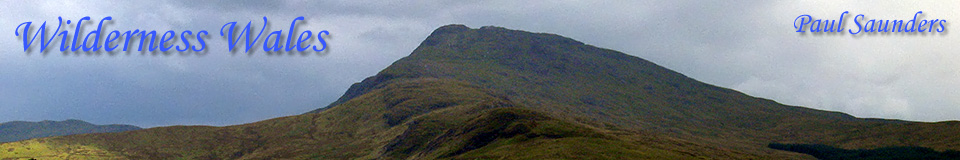
My First MountainFan Brycheiniog - May 1982This month (May 2007) is special. Not only is it the eighth anniversary of my website, it’s also the twenty-fifth anniversary of my first mountain ascent, up Fan Brycheiniog in the Brecon Beacons. Unfortunately I don’t know the exact date, but I do know that it took place in May 1982. So I’ve now been climbing mountains for 25 years! So here’s an historic trip report to mark the occasion. Unfortunately I have no photos of the event. Even though I owned a camera at the time, another two and a half years were to pass before I was inspired to become a landscape photographer. Thus most of my early adventures took place in a kind of “outdoor dark ages”. A pity, but there’s not a lot I can do about it now! The Ascent of Fan Brycheiniog It was a fine, sunny day. I’d climbed a handful of small hills during the previous month, but this time I was getting more adventurous and wanted to climb something bigger. The field next to the Gwyn Arms at Glantawe had always been a favourite picnic spot for my family, and I’d often noticed the hills around there. I fancied exploring them. Using my trusty road atlas, I noticed a trig point some distance north-west of the Gwyn Arms, located in the large, empty white space between the roads. This was the map I used to plan my first hill walks. At the time I naively assumed that all trig points marked summits, but I knew nothing of peak bagging and summit lists back then. As for navigation equipment, none was needed. It was a sunny day and I could see that the top was “over there somewhere”. Likewise no walking equipment was needed. It was dry so trainers would be fine. It was warm so a T-shirt would be fine, and it obviously wasn’t going to rain, so waterproofs weren’t necessary either. No need for a rucksack since I wasn’t carrying anything. Food and water weren’t an issue since it probably wasn’t going to take that long. So T-shirt, jeans and trainers it was then. Hill walking was so much simpler in the old days! I was accompanied by my then girlfriend Alyson. She’d always been happy to accompany me on our many walks in the outdoors (mainly short walks on the Gower coast), but she hadn’t yet realised that mountains weren’t really her cup of tea. The Ascent I presume that we started from the Gwyn Arms, but I’m not 100% sure how we got onto the hill. We may have followed the River Tawe for a short distance before reaching a “Private: No Entry” sign, then perhaps backtracked and made our way past the farm at Carreg Haffes. From there I think we headed through the fields up to Allt Fach at 463m. Since we had no map our direction was simply “up”. From there we followed the Fan Hir ridge, and I recall being amazed at the view over the cliff edge. On reaching the summit at 761m, we saw the trig point atop Fan Brycheiniog in the distance, and realised with disappointment that this wasn’t “the top”. Of course it was the top of Fan Hir, but having no concept of peak bagging at the time, I didn’t realise we’d actually bagged a summit. As far as I was aware, there was only one “top” and that was marked by the trig point. Alyson groaned at the prospect of descending to the col to face yet more ascent to the summit, but she accepted the challenge with good grace. I don’t recall how hard it felt at the time. I was young and fit and one tends to forget that sort of thing anyway. I don’t remember it feeling particularly difficult, but I think Alyson was getting a bit tired. When we finally reached the trig point on Fan Brycheiniog at 802m, Alyson breathed a sigh of relief. I however, looked onward and saw another high point on the ridge, and I wondered whether that might be higher still (it was Twr y Fan Foel, of equal height at 802m). I suggested continuing just in case, but Alyson would have none of it. As far as she was concerned, we’d reached the top. I agreed, after all, we were at the trig point! The Descent We may have stopped in the nearby summit shelter for a rest, I’m not sure, but I do know that we had nothing to eat anyway even if we had. We retraced our steps and descended to the col. At this point Alyson didn’t fancy climbing back up onto Fan Hir, and I saw no particular reason to do so either, so we started contouring around it instead. This led us to the Afon Haffes, which we started following. After all, it was going downhill, which was the right direction! We soon chanced up the wreckage of a Vampire which had crashed in 1953. It was spread over quite a large area and there was a lot of it remaining. At that time the wreckage was widely dispersed, but on a later visit I saw that much of it had been rearranged into the shape of the aircraft. We followed the Haffes for a while, but I was concerned that the river might lead us too far away from our starting point, so we left the river and continued contouring around Fan Hir. We didn’t reach the waterfalls or descend into the steep part of the Haffes valley. Instead I think we arrived back at pretty much the same place where we originally emerged from the fields, so we descended, passed the farm and found our way back to the car without any problems. I think we were a bit tired by the end of it, and we were certainly hungry. I seem to recall saying that next time we should bring a rucksack and carry some food. Conclusion On the whole, it was a memorable day out, and one which certainly inspired me to do more of the same in future, as well as instilling in me a love of the mountains that has lasted ever since. Distance estimate: 12.6km © Paul Saunders, 22nd May 2007 |
|
|
|
|
|
|
|
|
 Subscribe in a reader Subscribe in a reader |
||||
© Paul Saunders 1999-2010. All Rights Reserved.
|
||||
 Digg
Digg Delicious
 Reddit
 Stumbleupon
 Facebook